



Supervisor Rich Lettman Denounces MCAA Financial Mismanagement and Announces Mohave County Airport Takeover
FOR IMMEDIATE RELEASE October 22, 2026 Mohave County Supervisor Rich Lettman today issued a statement regarding the...

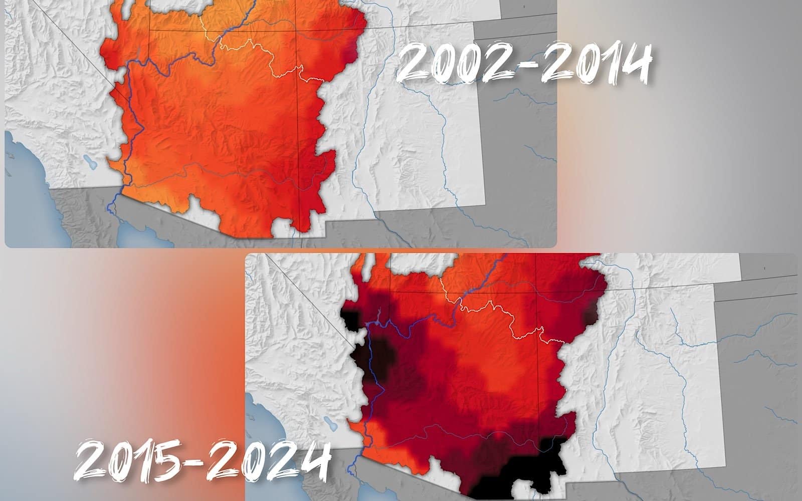
Amidst the arid landscapes you cherish, Arizona’s groundwater reserves are diminishing at an alarming rate. As someone who relies on the region’s water—whether for your home, farm, or community—you need to understand how accelerated groundwater loss threatens both your water security and the future of agriculture. Satellite data shows that over the past two decades, groundwater depletion has more than doubled, driven by changing climate patterns and increasing agricultural demands. Staying informed empowers you to engage in sustainable water practices and support efforts that protect this vital resource for generations to come.
You should understand that between 2002 and 2024, the Colorado River Basin lost about 27.8 million acre-feet of groundwater, an amount roughly equal to the storage capacity of Lake Mead. This depletion primarily affects the lower basin in Arizona, where 68 percent of the losses occurred. Since nearly 40 million people depend on this water, the scale of groundwater decline directly impacts your water security and agricultural sustainability in the region.
When you look at the satellite data from NASA’s GRACE and GRACE-FO missions, you’ll see a clear acceleration in groundwater loss over the past two decades. The rate more than doubled from about 5 millimeters per year between 2002 and 2014 to 12 millimeters per year between 2015 and 2024. This information highlights how quickly water depletion is intensifying beneath your feet.
The advanced satellite technology used in this long-term study offers you a precise view of how groundwater levels have declined throughout the Colorado River Basin. By integrating gravity-based measurements with land surface models and precipitation records, researchers revealed the changing patterns of water extraction and natural replenishment. You can see that the shift from El Niño to persistent La Niña events reduced rainfall, compounding groundwater losses as agricultural demand, especially from water-intensive crops like alfalfa, cotton, and pecans, increased. These insights emphasize the urgency for managing your groundwater resources wisely to avoid further decline.
You may not realize how much El Niño and La Niña events shape the Southwest’s water supply. Between 2014 and 2023, La Niña cycles, including a “triple-dip” phase, caused reduced winter rainfall in the Colorado River Basin. This drop in precipitation slowed aquifer replenishment, intensifying groundwater losses. Understanding these natural climate shifts helps explain part of why southern Arizona’s water reserves have been shrinking more rapidly during recent years.
Climate shifts like persistent La Niña conditions have intensified the decline of groundwater in Arizona. From 2015 to 2024, the rate of groundwater loss more than doubled compared to the previous decade, reaching 12 millimeters per year. This means your local aquifers are depleting faster due to decreased rainfall and prolonged dry spells driven by changing climate patterns.
Beyond just less rain, these climate cycles affect how and when water replenishes underground sources. The reduced snowfall and altered precipitation timing limit water flowing into aquifers, which compounds over time. When you combine this with increased water demand, especially for agriculture, the impact on groundwater becomes even more severe. The accelerated depletion warns you about the mounting challenges to secure Arizona’s water future.
You might be surprised to learn that industrial agriculture is one of the biggest users of groundwater in Arizona, consuming about 72 percent of the state’s available water supply. Since around 2014, large-scale farms growing alfalfa, cotton, corn, and pecans have expanded rapidly, especially in southern Arizona counties like La Paz, Maricopa, and Cochise. This surge in agricultural activity has greatly increased groundwater extraction, contributing directly to the rapid depletion of aquifers that support nearly 40 million people in the Colorado River Basin.
Your water use choices in agriculture have a significant impact, especially when relying on flood irrigation—a common method in Arizona. Though often the cheapest, flood irrigation releases water into trenches that flood crop fields, leading to higher evaporation and water loss compared to efficient methods like drip irrigation. This technique is widely used for thirsty crops such as alfalfa and cotton, accelerating groundwater depletion and worsening Arizona’s aquifer decline.
Flood irrigation, by its very nature, wastes large volumes of water because much of it evaporates or seeps away rather than directly nourishing crops. When applied to water-intensive crops like alfalfa, cotton, and pecans, this method can dramatically increase groundwater consumption, especially in a drought-prone region like Arizona. You should be aware that alternative irrigation technologies, including drip and sprinkler systems, can greatly reduce water loss by delivering moisture directly to plant roots. Adopting these can slow the alarming acceleration of groundwater depletion, helping to protect your water security and the environment.
You can learn from Arizona’s proactive approaches to groundwater conservation, which have shown promising results. For example:
These targeted policies have helped mitigate the continued decline of aquifers, especially in southern Arizona.
You can utilize advanced technology alongside sound policy to better manage groundwater resources. NASA’s GRACE and GRACE-FO satellite missions provide precise data on groundwater changes across the basin, enabling informed decision-making. Tools like OpenET allow you to optimize irrigation by measuring actual crop water use, helping to reduce excessive groundwater withdrawal. When combined with enforcement of management areas and irrigation restrictions, these technologies support sustainable water use practices that slow the rate of aquifer depletion.
By integrating satellite observations with local water policies, you have the opportunity to actively monitor and respond to groundwater loss with greater accuracy. This approach promotes efficient agriculture and water conservation in a region where irrigation consumes about 72 percent of available water. Ongoing collaboration between technology providers and policymakers strengthens your ability to protect Arizona’s limited groundwater supplies for future needs.
Groundwater levels in Arizona are expected to continue declining if current trends persist, with losses accelerating from 5 millimeters per year between 2002–2014 to 12 millimeters per year from 2015–2024. This decline threatens the viability of agriculture, especially in regions relying heavily on groundwater for water-intensive crops like alfalfa, cotton, and pecans. Without effective management, these diminishing supplies could jeopardize food production and water security for millions depending on the Colorado River Basin’s aquifers.
You can play a role in advancing sustainable water use by supporting collaborative management efforts like Arizona’s Groundwater Management Act, which has helped reduce losses in active management areas. Combining satellite data tools with local action enables better irrigation practices and more informed decisions, helping balance agricultural demands with aquifer health to secure future water resources.
Building on these efforts, collaboration between farmers, policymakers, and scientists is important for sustainable groundwater management. Tools like NASA’s OpenET platform provide real-time data on water evapotranspiration, helping you optimize irrigation and reduce waste. Engaging in groundwater management areas and promoting efficient irrigation methods beyond flood irrigation can help slow aquifer depletion. By working together and using technology-driven insights, you support both your agricultural productivity and the long-term health of Arizona’s important water supplies.
To wrap up, you should be aware that Arizona’s groundwater levels are dropping rapidly, driven by increased agricultural use and shifting climate patterns. If you rely on this water, it’s important to understand that managing groundwater sustainably is necessary to prevent further depletion. Efforts like active management areas are helping slow losses, but the challenge remains significant. Staying informed about water use and conservation methods can help you contribute to protecting this vital resource for your community and future generations.
FOR IMMEDIATE RELEASE October 22, 2026 Mohave County Supervisor Rich Lettman today issued a statement regarding the...

FOR IMMEDIATE RELEASE October 22, 2026 New ADA Parking and Complimentary Paratransit Shuttle Service for Laughlin...
FOR IMMEDIATE RELEASE October 22, 2026 Kingman, AZ – The 20th Annual Walk Away from Drugs has been rescheduled for...
0 Comments